An Introduction to the Geology of the Tsumeb Mine, Namibia
Clive H.M.King: BSc (Hon.), MSc, FGA, Pr.Sci.Nat
Clive King worked for Tsumeb Corporation Ltd (TCL) as an underground mine geologist at the Tsumeb Mine from 1979 to 1984. After spending one year on sabbatical leave visiting mining camps in the US and Canada, he returned to Tsumeb to undertake field exploration in the Otavi Mountainland, which led to the discovery of the Khusib Cu-Ag deposit. Clive resigned from TCL as Chief Geologist in 1997 to join Samax Resources (which later became Axmin Resources), to explore for gold in West Africa. He is now a geological consultant, living in Mombasa, Kenya.
Introduction
The Tsumeb Mine is well known amongst geologists, mineralogists and especially mineral collectors as the “mecca” for some of the world finest mineral treasures. The geology of this unique lead-copper-zinc-silver ore deposit was first described in a definitive paper by Söhnge (1964). This was succeeded, however, by Lombaard et al. (1986) who provided an updated account based on a collation of work by a succession of geologists stretching back to the 1920s, including Schneiderhöhn, Griffiths, Lombaard, Kruger, Günzel, and Innes. Their paper included descriptions of the mineralogical and geochemical features over the entire c.1700 metres depth of the vertical “pipe-like” structure at Tsumeb, as well as various hypotheses on ore genesis.
Less formal summaries of the geology have been published in the Mineralogical Record (Weber and Wilson 1977), by Gebhard (1999) and Von Bezing et al. (2007). The current author was the underground mine geologist in the early 1980s at the time when research for the Lombaard et al. paper was underway. Besides being involved in mapping the working faces in the upper parts of the Tsumeb Mine, from surface to 6 Level, and the lower levels between 30 to 44 levels, the writer was fortunate to have participated in the discussions of the geology and genesis of this intriguing deposit with Andries Lombaard and his co-workers. Lively discussion on the genesis of the deposit was commonplace within the TCL geology department which, at the time, generated further ideas to be used as exploration models in searching for similar style mineralisation in the Otavi Mountainland. Underground mine tours were conducted on a regular basis by the writer, often culminating with interesting discussions at the working face, ranging from geology to mineral paragenesis.
Regional Geology
The Tsumeb mine is located in the northern region of Namibia (Figure 1) and is hosted within a thick sequence of Neoproterozoic (+660 million year-old) carbonate rocks that form the Northern Carbonate Platform. These shelf deposits, made up of algal, stromatolitic and oolitic dolomites and limestones with interspersed shale/mudstone horizons, have been divided into the Lower Abenab and Upper Tsumeb Subgroup carbonate sequences. Together, these subgroups make up the Otavi Group carbonates which attain a maximum thickness of some 6700 metres. They are underlain by the basement rocks of the Grootfontein Granite complex and intermediate Nosib Group siliclastic sediments as well as being unconformably overlain in places by the younger Mulden Group (Tschudi Formation) arkosic sandstones. The Tsumeb deposit, stratigraphically situated within the upper part of the Tsumeb Subgroup carbonate sequence, is located on the northwestern limb of the Tsumeb geosyncline. It forms an irregular “pipe-like” structure that transgresses some 1700 metres of the upper part of the Tsumeb Subgroup dolomites. It has, in places, been affected by bedding-slip shears resulting from the regional folding of the Tsumeb Syncline. The pipe structure has been attenuated and “thinned out” along such bedding-slip shears between 7 Level and 20 Level (the “Grosse Überschiebung” shear) before it cuts down through the carbonate beds at a high angle between 20 Level and 35 Level (Figure 2). On 12 Level, the plan dimensions of the ore body are only 25 metres by 6 metres (Lombaard et al. 1986). The pipe is again offset and attenuated between 35 Level and 37 Level before it steepens to near vertical. In plan, it is typically elliptical in shape, varying in size with its long axis trending northwest – southeast. It reaches its maximum surface projection on 26 Level where the axes of the ellipse measure 225 metres by 90 metres (Figure 2).
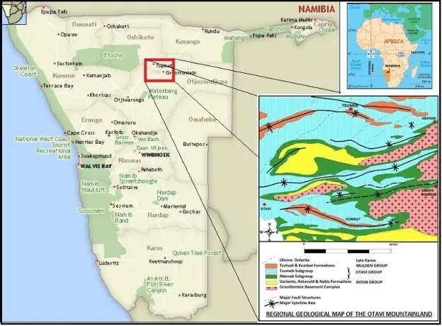
Figure 1: Location map of Namibia showing the town of Tsumeb, positioned on the northwestern limb of the Tsumeb Syncline in relation to the geology of the Otavi Mountainland. (modified after Lombaard et al. 1986).
Tsumeb Mine Geology
The locus of the Tsumeb pipe structure, besides hosting massive and disseminated sulphides, is characterised by a core of feldspathic sandstone and sandstone breccias, as well as dolomite breccia which, in turn, have undergone various degrees of hydrothermal alteration, especially in the lower levels of the pipe. Hypogene gangue minerals, namely calcite, quartz, and quartz/carbonate mixtures, have infilled open spaces in the breccia as well as partly replacing the breccia itself. The breccia has in places undergone folding, arcuate fracturing and intense shearing during regional deformation due to the marked differences in competency between the country dolomites and the pipe infill.
The arcuate fractures form the perimeter of the elliptical structure and join at its western end, defining a horseshoe-shaped “shell”, which is often infilled/replaced by massive sulphides containing more than 40 percent total metal across widths of up to 25 metres. These fractures are particularly well developed in the upper part of the mine down to 12 Level and again between 20 Level and 30 Level, where they are referred to as the North and South Veins. The thickness of the North Vein surpasses that of the South Vein below 28 Level. Bedded dolomites within the horseshoe structure define a synclinal east-west trending fold, mapped by the mine geologists as the Ore Body Syncline Fold Zone. These fold axes terminate eastward against the feldspathic and dark dolomite breccia plugs that are central within the steeply sectioned portion of the pipe down to 35 Level. The Ore Body Syncline fold is often accompanied by an anticline fold, the hinge-line of which is often located just south of, or within, the South Vein structure. The Ore Body Syncline Fold Zone continues eastwards into the country dolomites, beyond the eastern limit of the pipe structure, unlike on its western perimeter. Together with the anticlinal fold, the synclinal fold has been traced vertically from 19 Level down to the lowest workings mapped at 44 Level.
The dark dolomite breccia “plug”, consisting predominantly of black dolomitic mudstone with some argillite, is prominent from 21 Level to 30 Level, diminishing in volume together with the feldspathic sandstone down to 35 Level. The breccia, comprising ill-sorted angular dolomite and chert fragments, some of which have been traced back to specific horizons in the upper Tsumeb Subgroup some 1000 metres above their present location, forms a competent plug-like body within the pipe. Only the southern contact of the breccia with the South Vein shows signs of shearing, deformation and increased mineralisation. Generally, the main body of the dark dolomite breccia remains relatively inert with little to no alteration or mineralisation affecting it. Also present is a light to medium grey dolomite breccia that becomes more prominent at the expense of the dark dolomite breccia from 35 Level downwards and fills the bulk of the pipe structure to the lowest-most levels of the mine. The matrix of this breccia, unlike that of the dark grey dolomite breccia, has, in part, been intensely altered by calcitisation and silicification. It is foliated and contains moderate sulphide mineralisation aligned with the foliation and around the breccia fragments. In places, the calcitisation and foliation have been so intense that the resulting breccia is referred to as a “marble breccia”. Similarly, as the intensity of silicification increases down the pipe from 34 Level, a “silica dolomite foliated breccia” occurs together with the marble breccia. Silicification becomes the dominant alteration type below 36 Level and by 44 Level defines the outline of the pipe (Figure 2).
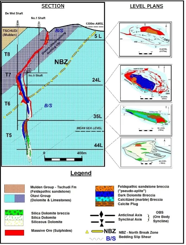
Figure 2: Simplified geological section of the Tsumeb Orebody showing the elliptical character of the pipe, as per level plans, from near surface down to 44 Level (compiled and modified from Lombaard et al. 1986).
A large “plug” of crystalline calcite is present in the northeastern part of the pipe, extending from 32 Level down to 36 Level. The calcite plug is host to many mineral pockets containing various forms of calcite crystals. Some of the vugs are covered with botryoidal coatings of dark, olive-green mottramite.
It is on the northern side of the pipe on 28 Level that a significant and strategically important dolomite bed, marked by small carbonate-filled vugs and attaining a thickness of some 5 metres is exposed in the underground workings. A distinctive stromatolitic marker bed is situated 50 metres stratigraphically above this horizon. Both units have been mapped out on surface. The vuggy textured unit has been interpreted to have been a permeable horizon representing a palaeo-aquifer (Hughes 1979) and is referred to as the North Break Zone. It has played an exceedingly important role in the genesis of the Tsumeb pipe structure. Furthermore, it is responsible for the formation of a subsidiary solution collapse breccia body situated some 80 metres north of the main pipe and extending vertically for some 50 metres between 26 and 27 levels known as the North Break Zone ore body. This breccia body was richly mineralised, containing some 100,000 tonnes of ore at 16 percent combined copper, lead and zinc (Lombaard et al. 1986).
Just above and below the interception of the North Break Zone at 30 Level, a number of lenses of massive sulphides, referred to as “mantos” exist in the country rocks immediately to the north and south of the pipe (Figure 3). Mapping suggests that localized folding is responsible for the localisation of these massive sulphide bodies. Such ore, due to its high metal content was often selectively mined and then trammed to surface where it was taken directly to the smelter for beneficiation. Furthermore, thin, isolated, and discontinuous lenses of feldspathic sandstone are found in the country dolomites to the northwest and to the southeast from the pipe in the vicinity of the North Break Zone and the manto bodies. Such lenses are thought to have formed by the “squeezing out” of the sandstone from the pipe into open spaces created by localized folding, similar to that of the manto bodies. The S110 ore body, comprises one of these sandstone lenses, partly replaced by chalcocite, and is located on the southeast side of the pipe on 30 Level (Figure 3). It was mined for many years from the mid-1970’s through to the early 1980s and produced many spectacular specimens of dioptase and wulfenite. It is within this section of the pipe (26 Level to 30 Level) that the greatest amount of metal tonnes per vertical metre was mined from the deposit. Thereafter, the ore diminishes in quality and grade down the length of the pipe, becoming more and more restricted with increased silicification below 38 Level.
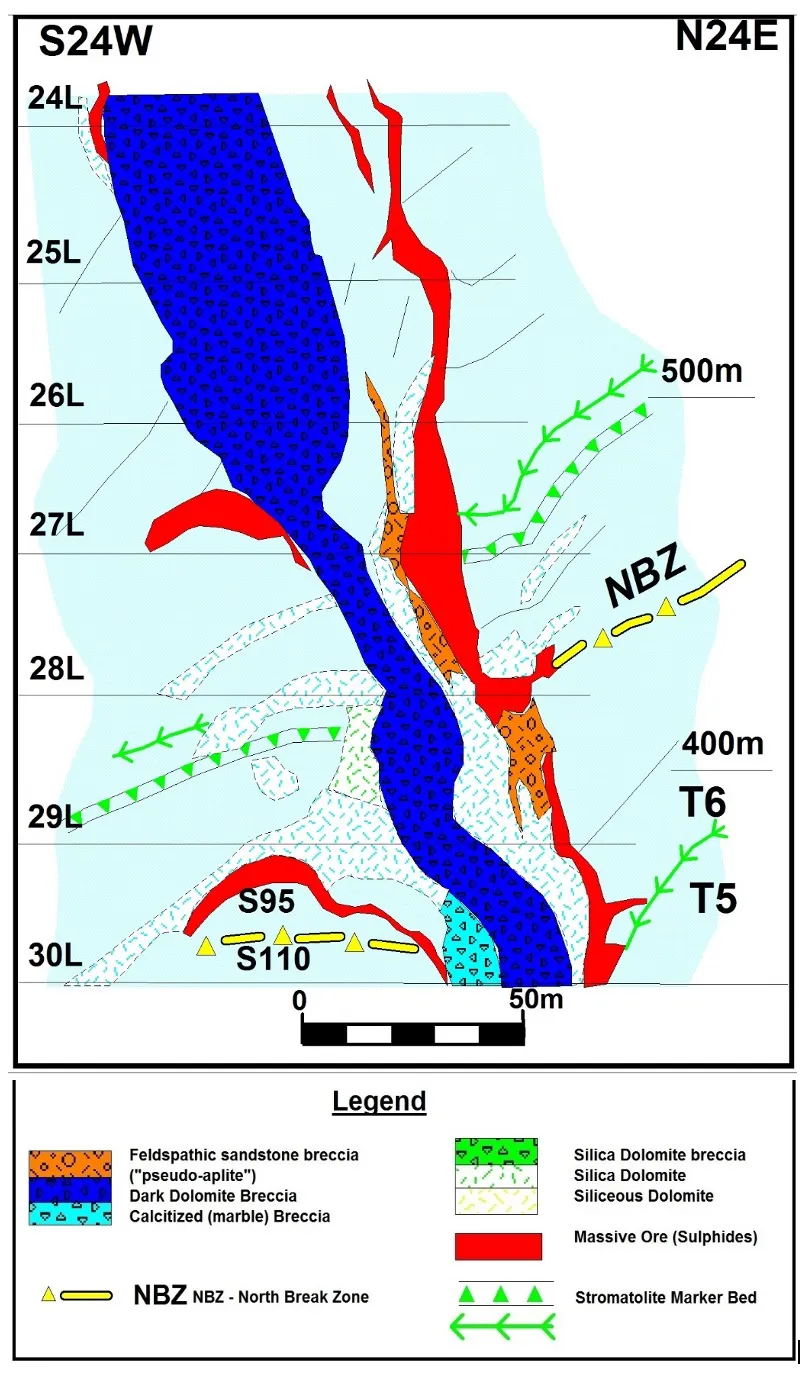
Figure 3: Geological section between 24 Level and 30 Level showing the relationship of the North Break Zone (NBZ), and the presence of the “manto” massive sulphide ore bodies extending out from the pipe and into the country dolomite beds (modified after Lombaard et al. 1986).
Mineralogy
Tsumeb’s vast array of secondary mineral species would not have formed if it were not for the three vertical zones of oxidation that occurred in the mineralised pipe structure.
-
First oxidation zone: Surface to 11 Level represented by the vadose zone and influenced by fluctuations of the water table. Oxide minerals are found in much reduced quantities between 11 Level and 15 Level.
-
Second oxidation zone: 24 to 35 Level – centred around the intersection of the North Break Horizon with the Tsumeb pipe on 29 Level.
-
Third oxidation zone: From 42 Level downwards. Note: The third zone of oxidation was not officially recognised when the author undertook the drilling on 40 level in 1984. Later, deeper level exploration, followed by mining, revealed evidence of oxidation in the lower levels (Gebhard 1999; Melcher 2003).
The main hypogene ore minerals include bornite, chalcocite, tennantite, enargite (mainly in the upper levels of the mine), galena, and sphalerite. Disseminated pyrite is often present, becoming more important with silicification below 35 Level. Minor amounts of germanium ores such as germanite and renierite were important in the higher levels of the mine at 5 and 6 levels as well as between 20 Level and 30 Level.
The distribution of both primary and secondary ore minerals within the zones of oxidation is highly irregular with both ore types commonly intermixed. Vugs of secondary minerals are often found within massive hypogene ores. For example, many of the famous Tsumeb reticulated or “honeycomb” cerussites were found in vugs within the massive galena of the South Vein on 25 and 26 Levels.
Minor amounts of precious metals, particularly silver, are found within some of the hypogene copper ores with tennanite being the main argentiferous mineral. The silver-to-copper ratio increases notably with depth. The gold grade is very low and appears to be associated with chalcopyrite which is a minor ore mineral.
The spatial relationships and the textures in the hypogene ores indicate that they were precipitated in overlapping events commencing with pyrite, then copper minerals, and ending with galena and various low temperature gangue minerals. This paragenesis is the result of changing ore fluid chemistry, temperature, and pressure during multiple mineralisation pulses within the deposit as depicted in Figure 4. The age of mineralisation as determined from Pb-Pb radiometric dating is given as between 550 to 580 million years (Holmes and Cahen 1957) at which time the overlying Mulden sedimentation was taking place.
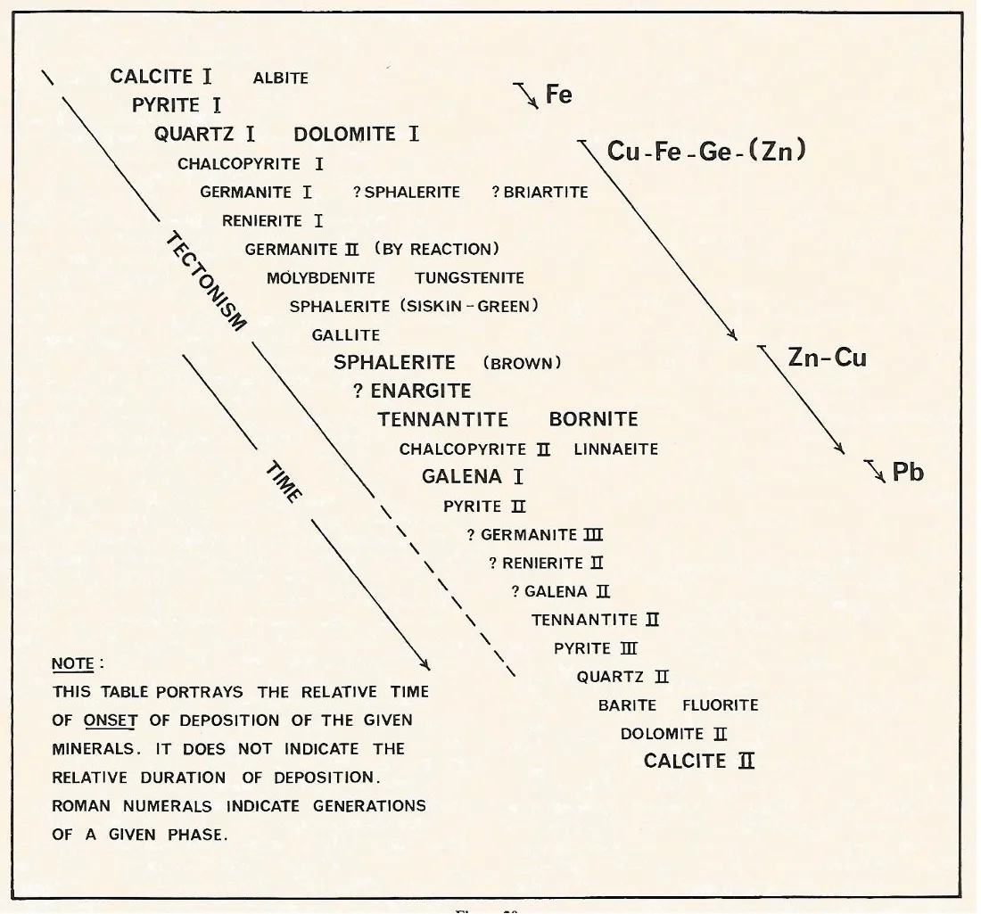
Figure 4: Paragenesis of the hypogene minerals in the Tsumeb deposit (after Lombaard et al. 1986).
The paragenesis of the secondary minerals is extremely complex and is beyond the scope of this geological introduction.
Genesis
The genesis of the Tsumeb ore body was centred on the presence of the feldspathic sandstone and dolomite breccias within a pipe structure. A number of hypotheses from volcanogenic to sedimentary origins have been put forward and have been summarised by Lombaard et al. (1986). One of the earliest ideas was presented by Schneiderhöhn (1919) who interpreted the feldspathic sandstone as a “pseudo-aplite” of igneous origin. It was only much later that the feldspathic sandstone in the pipe structure was correlated with the arenaceous rocks of the overlying Mulden Group sandstone (Le Roex 1955); nevertheless, the term “pseudo-aplite” continued to be used to describe this material, despite the fact that it was recognised to be of sedimentary origin.
In the 1970’s the pipe breccias became recognised as the product of internal dissolution of the dolomite beads (Callahan 1971; Thirion 1973 – unpublished TCL reports). Percolating meteoric waters were believed to have been responsible for initiating karstic activity along an earlier zone of weakness, such as the Ore Body Fold Zone, thought to be representative of an earlier Damara fold event (Lombaard et al. 1986). However, in order to accommodate dissolution at such depths below surface, Hughes (1979) proposed that there had to be a second zone of meteoric influx. The presence of the manto as well as the North Break breccia ore bodies and increased levels of oxidation indicated that such a zone existed, intersecting the pipe between 28 and 30 levels. It was identified and interpreted from its vuggy texture to be a palaeo-aquifer and was subsequently named the North Break Zone. Dissolution progressed vertically, both downwards and upwards through the carbonate units along the line of weakness created by the Ore Body Fold Zone (Figure 5). Once the lower part of the dissolution pipe, initiated at the North Break Zone, encountered the surface sinkhole, the pipe system was effectively open to the surface, allowing feldspathic sandstone and breccia fragments to be washed into the karst structure.
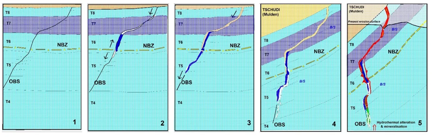
Figure 5: Schematic sequence of events that created the Tsumeb Pipe structure: (1) Initial formation of the Ore Body Fold zone through the overlying carbonate sequences, related to an early Damara event in the underlying basement. (2) This line of weakness was the loci for dissolution by meteoric waters commencing at the intersection of the North Break paleo-aquifer and from surface, resulting in formation of the Dark Dolomite karst breccia, mainly derived from the T7 horizon. (3) Dissolution proceeded along the Ore Body Fold zone both downward and upward before tapping into the overlying Mulden Group sandstone resulting in a slurry and agglomerate of feldspathic sandstone material collapsing into the karst pipe and becoming mixed with the Dark Dolomite breccia. (4) Regional folding disrupted the carbonate sequence and especially the pipe structure resulting in the attenuation of the pipe through bedding slip failures. Possibly coeval with this event was the ascent of hydrothermal fluids causing rock alteration leading to further dissolution and collapse of the karst breccias and the formation of the arcuate fractures represented by the North and South Veins. (5) Saline, metal-bearing hydrothermal fluids ascended the pipe structure. The sudden drop in temperature and pressure caused metal deposition in open space fillings as well as partial replacement of both the dolomite and feldspathic sandstone. The waning stages of mineralisation and alteration overlapped with the end of regional deformation. Source: TCL Geology Department study (unpublished).
Regional folding, with the development of the Tsumeb syncline, resulted in the deformation of the pipe which contributed to further collapse within the structure. The foliation fabric in the mineralised marble and silica dolomite breccias provides evidence for this.
The timing of the primary mineralisation succeeded the initial development of the pipe structure and continued through to the waning stages of regional folding and deformation. In fact, it appears from the overlapping brecciation and alteration events recorded in the mine, that the early transcending hydrothermal mineral fluids may in part have been responsible for continued dissolution and brecciation within the pipe besides causing rock alteration and depositing metal sulphides. The North Break aquifer has played a significant role in further oxidizing the metal sulphides leading to the deeper zones of oxidation and greatly enhancing mineral specimen creation within the deposit.
Conclusion
The Tsumeb mine and its associated mineral wealth is unique among the world’s polymetallic base metal deposits. Although similar but much smaller solution karst structures are present in the Tsumeb area, not all are mineralised and certainly not to the extent of the Tsumeb deposit; some, however, like the Tsumeb West deposit, have been mined for their oxide copper.
Within the Otavi Mountainland carbonate sequence there are numerous showings of base metal mineralisation. Vanadium mineralisation is found as fillings in karst-filled “sand-sacks” at various localities within the Mountainland. Well known is Berg Aukas which at one time was a working lead-zinc-vanadium mine that produced spectacular descloizite crystals before its closure in the late 1970s. The question that has been on every earth scientist’s lips is: could there be another Tsumeb deposit lurking undiscovered in the Otavi Mountainland? The discovery of the subsurface, high grade Khusib Springs copper-silver deposit, some 40 kilometres south-east of Tsumeb in the 1990s, indicates that there are massive sulphide ore bodies still to be found in the Mountainland . As the old adage goes – “to hunt elephants, one needs to go to elephant country!” In the writer’s opinion, the Northern Carbonate Platform has yet to reveal all its hidden secrets and one day, through persistent and dedicated exploration, hopefully new discoveries will be made. It would indeed be a happy day if another Tsumeb is discovered!